Garmin GPSMAP 722xs Plus Radar Pack Basemap GMR18HD+ radar #010-02320-50
Original price was: $2,174.98.$299.99Current price is: $299.99.

Description
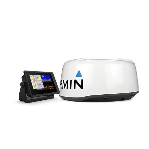
Garmin 010-02320-50 Chartplotters
Garmin GPSMAP722xs Plus Radar
Pack Worldwide Basemap with GMR18HD+ radar
Model: 010-02320-50
- Easily integrate with more engines
- Connect to your favorite third-party devices
- Easily build your marine system using the best of network connectivity
- Compatible with premium maps and charts for the best in Garmin navigation
- See below your boat with built-in sonar capabilities (transducers sold separately)
- Manage your marine experience from nearly anywhere
The bright, sunlight-readable 7″ intuitive touchscreen chartplotter with enhanced map drawing is easy to use in any environment and seamlessly integrates into your Garmin marine system.
Get built-in support for 1 kW CHIRP traditional sonar for superior target separation and ClearVü scanning sonar to see up to 1,000’ below your boat at 260 kHz (transducer sold separately).
Pair with Panoptix or Panoptix LiveScope™ easy-to-interpret live sonar (transducer sold separately) to see all around your boat in real time.
These optional charts offer the best of Garmin and Navionics® data, Auto Guidance technology and other premium navigation features1.
If you have multiple Garmin devices on your boat, you can share information — such as maps, user data, radar and IP cameras — among them.
Connect to autopilots, digital switching, weather, FUSION-Link™ audio system, media, VHF, AIS and more from one screen.
Built-in Wi-Fi® connectivity pairs with the free all-in-one mobile app for access to the OneChart™ feature, smart notifications2, software updates, Garmin Helm, Garmin Quickdraw™ Community data and more.
Connect with some of your favorite devices, such as quatix® marine watches, gWind™ Wireless 2 transducers, GNX™ Wind marine instruments and wireless remote controls.
Now you can connect your chartplotter to different kinds of engines, including Yamaha engines.
ONEHELM™ FEATURE – This exclusive feature brings together all the operations and capabilities of third-party devices, such as EmpirBus™ digital switching, on one screen.
Specifications
| General | |
| Physical dimensions | 8.8″ x 5.6″ x 2.1″ (224.0mm x 142.5mm x 53.9mm) |
| Display size | 6.1″ x 3.4″; 7.0″ diagonal |
| Display resolution | 800 x 480 pixels |
| Display type | WVGA display |
| Weight | 2.4 lbs (1.1 kg) |
| Water Rating | IPX7 |
| Polarized Support | Yes |
| J1939 Compatible | Yes |
| Power consumption | Max power usage at 10 Vdc: 24 W |
| Antenna | Internal or external over NMEA 2000 |
| Mounting options | Bail or flush |
| Receiver | 10 Hz high-sensitivity |
| Garmin Marine Network™ ports | 1 |
| Maps & Memory | |
| Preloaded maps | Worldwide basemap |
| Accepts data cards | 2 microSD™ cards; 32 GB max |
| Waypoints | 5,000 |
| Routes | 100 |
| Track log | 50,000 points; 50 saved tracks |
| Outdoor Recreation Features | |
| Tide tables | Yes |
| Chartplotter Features | |
| Garmin Radar compatible | Yes |
| Garmin Sonar compatible | Yes (built-in) |
| Garmin SmartMode compatible (customizable monitor presets) | Yes |
| Supports AIS (tracks target ships position) | Yes |
| Supports DSC (displays position data from DSC-capable VHF radio) | Yes |
| Supports FUSION-Link™ compatible radios | Yes |
| GSD™ Black Box sonar support | Yes |
| GCV™ Black Box sonar support | Yes |
| ActiveCaptain compatible | Yes |
| GRID™ (Garmin Remote Input Device) compatible | Yes |
| Wireless remote compatible | Yes |
| Sailing Features | Yes |
| Sonar Features & Specifications | |
| Dual-frequency (50/200 kHz) sonar capable | Yes |
| Dual-beam (77/200 kHz) sonar capable | Yes |
| Frequencies supported | Traditional: 50/77/83/200 kHz |
| Transmit power | 1 kW traditional; 1 kW CHIRP |
| CHIRP sonar technology | Yes (Built-in) |
| ClearVü | Yes with CHIRP (built-in) |
| SideVü | Yes (with external black box, sold separately) |
| Maximum depth | 5,000 ft at 1kW (depth capacity is dependent on water bottom type and other water conditions) |
| Bottom lock (shows return from the bottom up) | Yes |
| Water temperature log and graph | Yes |
| Sonar recording | Yes |
| Sonar history rewind | Yes |
| Connections | |
| NMEA 2000® compatible | Yes |
| Transducer pin numbers | 8-pin (blue) |
| NMEA 0183 input ports | 1 (Differential) |
| NMEA 0183 output ports | 1 (Differential) |
| Video input ports | 1 BNC |
| Video output ports | None |
| Wireless connectivity | Yes |
What’s in the Box:
- Chartplotter
- GPSMAP 722xs Plus chartplotter
- Power cable
- Bail mount with knobs
- Flush mount kit with gasket
- Protective cover
- Trim piece snap covers
- Documentation
- Radar
- GMR 18 HD+ radome
- Power cable (15 m)
- Network cable (15 m)
- Installation instructions
- Mounting template
Normalized SKU: 0100232050
UPC Code: 753759240752