Garmin BlueChart® g3 Vision® HD – VUS032R – Southern Gulf of Mexico – microSD™/SD™
Original price was: $281.99.$70.50Current price is: $70.50.

Description
Experience unparalleled coverage and brilliant detail when you’re on the water with charts that feature integrated Navionics ® data, Auto Guidance technology and more.
Garmin 010C073300 Attributes
- Compatibility: Compatible With Chart Plotters
- Chart Coverage: VUS032R Southern Gulf of Mexico Coastal
- Storage: On SD/ Micro-SD Card
Garmin 010C073300 Features & Benefits
- Provides Exceptional Coverage, Clarity And Detail With Coastal Charts That Feature Integrated Garmin And Navionics ® Data
- Auto Guidance Technology Calculates A Route Using Your Desired Depth And Overhead Clearance And Provides A Suggested Path To Follow
- Certain Areas Offer High-Resolution Relief Shading, Which Combines Color And Shadow To Give You An Easy-To-Interpret, Clearer View Of Bottom Structure
- Provides Depth Range Shading For Up To 10 Depth Ranges, Enabling You To View Your Target Depth At A Glance
- Up To 1 Foot Contours Provide A More Accurate Depiction Of The Bottom Structure For Improved Fishing Charts
- To Give A Clear Picture Of Shallow Waters To Avoid, The Shallow Water Shading Allows For Shading At A User-Defined Depth
- High-Resolution Satellite Imagery With Navigational Charts Overlaid Gives You A Realistic View Of Your Surroundings
- FishEye View – This Underwater Perspective Shows 3-D Representation Of Bottom And Contours As Seen From Below The Waterline
- MarinerEye View – This View Provides A 3-D Representation Of The Surrounding Area Both Above And Below The Waterline
- Limited One Year Consumer Warranty
Garmin 010C073300 Warranties
- garmin-marine-warranty-policy.pdf
BlueChart® g3 Vision® HD – VUS032R – Southern Gulf of Mexico – microSD™/SD™
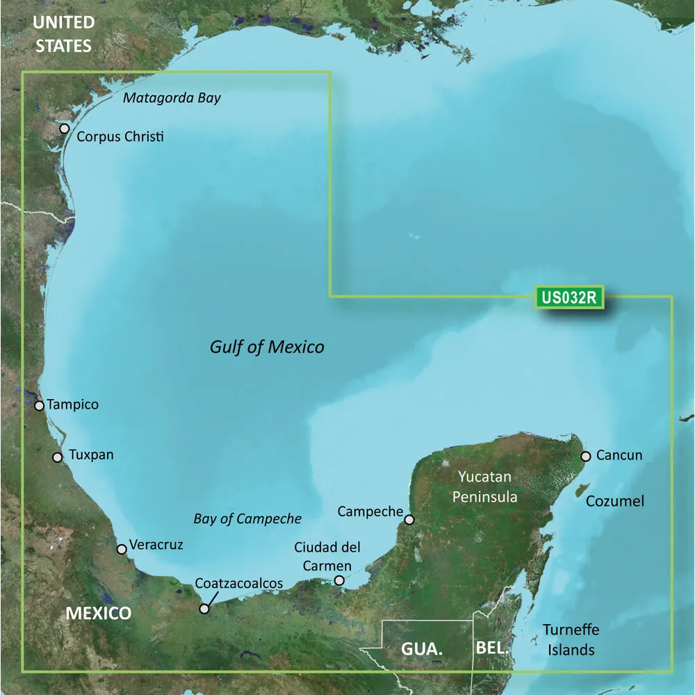
Coverage:
Covers the Gulf of Mexico from Matagorda Bay to Belize City, including Corpus Christi, TX, Veracruz, Mex., the Bay of Campeche, Cancun, Mex., and Cozumel, Mex.
Premier Coastal Navigation Charts
- Provides industry-leading coverage, clarity and detail with updated coastal charts that feature integrated Garmin and Navionics® data
- Auto Guidance¹ technology uses your desired depth and overhead clearance to calculate routes and show a suggested path to follow
- High-resolution relief shading combines color and shadow to give you an easy-to-interpret, clearer view of bottom structure than contour lines alone
- Depth Range Shading provides up to 10 depth ranges, enabling you to view your target depth at a glance
- Up to 1’ contours provide a more accurate depiction of the bottom structure for improved fishing charts and navigation in swamps, canals and marinas
Experience unparalleled coverage and brilliant detail on the water. BlueChart g3 Vision coastal charts provide industry-leading coverage, clarity and detail with integrated Garmin and Navionics data, Auto Guidance technology and high-resolution relief shading..
Auto Guidance Technology
The Auto Guidance feature¹ uses your desired depth and overhead clearance to calculate a route and a suggested path to follow.
High-resolution Relief Shading Feature
High-resolution relief shading combines color and shadow to give you an easy-to-interpret, clearer view of bottom structure than contour lines alone.
Up to 1’ Contours
The closer the contour lines, the more accurate the depiction of the bottom structure for improved fishing charts and navigation in swamps, canals and marinas.
NOAA Raster Cartography
If you prefer your display to have the look of paper charts, NOAA raster cartography2 is available as a free downloadable feature via the ActiveCaptain® app.
Depth Range Shading
This feature provides up to 10 depth ranges, enabling you to view your target depth at a glance.
Shallow Water Shading
This feature allows you to use shading to designate the shallow water depths you need to avoid.
High-resolution Satellite Imagery
These detailed images of ports, marinas, bridges and navigational landmarks help provide you with superior situational awareness.
Unique 3-D Views
MarinerEye and FishEye views provide additional perspective both above and below the water line.
¹Auto Guidance is for planning purposes only and does not replace safe navigation operations
²Raster cartography cannot be viewed on echoMAP CHIRP and ECHOMAP Plus combos but can be viewed on mobile devices via the ActiveCaptain mobile app
This product may not be returned to the original point of purchase.Please contact the manufacturer directly with any issues or concerns.
BlueChart g2 Vision provides the same rich detailed charts as BlueChart g2 to help you make the most of your equipment. In addition, g2 Vision also has an ever-growing high…!!!!—-
PRODUCT ID: 30386
SKU: NVN-30386
CSKU: CWR-30386
REWRITE: 41497-garmin-bluechart-g3-vision-hd-vus032r
MPN: 010-C0733-00
UPC: 753759069131
ASIN: B0040RIZXS
WSKU: GAR010C073300
SSKU:
KSKU: GCM010C073300
GSKU:
MSKU:
LSKU:
NAME: Garmin BlueChart® g3 Vision® HD – VUS032R – Southern Gulf of Mexico – microSD™/SD™
NAME_EX: GARMIN VUS032R SOUTHERN GULFMEXICO BLUECHART G3 VISION
PTITLE: Garmin BlueChart® g3 Vision® HD – VUS032R – Southern Gulf of Mexico – microSD™/SD™
TYPE: Cartography | Garmin BlueChart Vision
VENDOR: Garmin
Google Category: SOFTWARE > COMPUTER SOFTWARE > GPS MAP DATA & SOFTWARE
Amazon Category:
Amazon Title: Garmin vus032r southern gulf of mexico sd card + $150
Google Title: BlueChart g2 Vision – Southern Gulf of Mexico – Maps
Amazon Category:
Gtags:
| Garmin |
GSpecs: