Garmin BlueChart® g3 Vision® HD – VEU010R – Spain, Mediterranean Coast – microSD™/SD™
Original price was: $204.99.$51.25Current price is: $51.25.

Description
Experience unparalleled coverage and brilliant detail when you’re on the water. BlueChart ® G3 Vision coastal charts provide industry-leading coverage, clarity and detail with integrated Garmin and Navionics content.
Garmin 010C076800 Attributes
- Compatibility: Compatible With Chart Plotters
- Chart Coverage: VEU010R Spain And Med. Coast
- Storage: On SD/ Micro-SD Card
Garmin 010C076800 Features & Benefits
- Industry-Leading Coverage, Clarity And Detail With Updated Coastal Charts That Feature Integrated Garmin And Navionics ® Content
- Auto Guidance Technology Quickly Calculates A Suggested Route By Using Your Desired Depth And Overhead Clearance
- Provides Depth Range Shading For Up To 10 Depth Ranges, Enabling You To View Your Target Depth At A Glance
- Up To 1 Foot Contours Provide A More Accurate Depiction Of The Bottom Structure For Improved Fishing Charts
- To Give A Clear Picture Of Shallow Waters To Avoid, The Shallow Water Shading Allows For Shading At A User-Defined Depth
- High-Resolution Satellite Imagery With Navigational Charts Overlaid Gives You A Realistic View Of Your Surroundings
- FishEye View – This Underwater Perspective Shows 3-D Representation Of Bottom And Contours As Seen From Below The Waterline
- MarinerEye View – This View Provides A 3-D Representation Of The Surrounding Area Both Above And Below The Waterline
- Crystal-Clear Aerial Photography Shows Exceptional Detail Of Many Ports, Harbors And Marinas And Is Ideal When Entering Unfamiliar Ports
- Limited One Year Consumer Warranty
Garmin 010C076800 Warranties
- garmin-marine-warranty-policy.pdf
BlueChart® g3 Vision® HD – VEU010R – Spain, Mediterranean Coast – microSD™/SD™
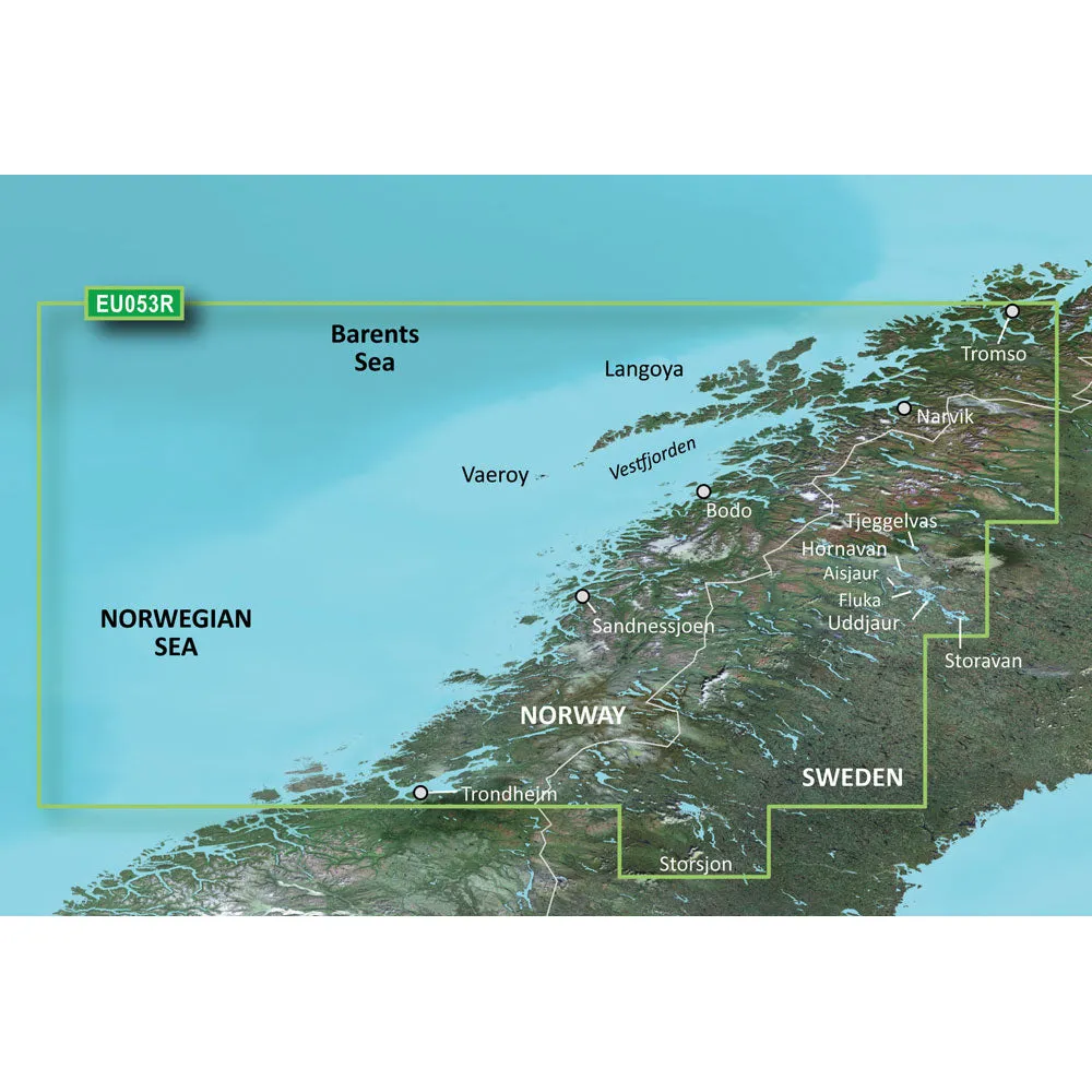
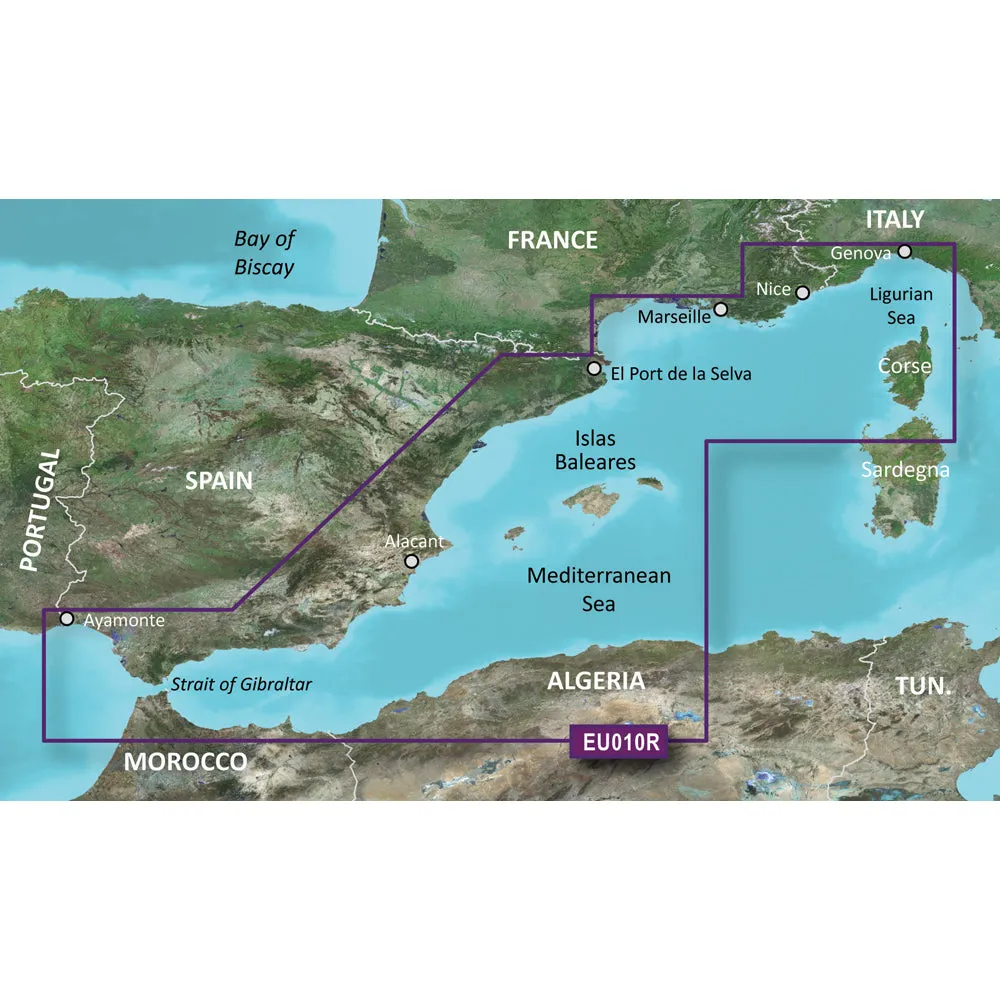
Coverage:
From El Port de la Selva to Ayamonte, including entire Spanish Mediterranean coast, Islas Baleares and Gibraltar.
Premier Coastal Charts
- Industry-leading coverage, clarity and detail with updated coastal charts that feature integrated Garmin and Navionics® content
- Auto Guidance¹ technology quickly calculates a suggested route by using your desired depth and overhead clearance
- Includes Depth Range Shading for up to 10 depth ranges, enabling you to view your target depth at a glance
- Up to 1’ contours provide a more accurate depiction of the bottom structure for improved fishing charts
- To give a clear picture of shallow waters to avoid, the Shallow Water Shading allows for shading at a user-defined depth
Experience unparalleled coverage and brilliant detail when you’re on the water. BlueChart g3 Vision coastal charts provide industry-leading coverage, clarity and detail with integrated Garmin and Navionics content.
Auto Guidance
Whether you are fishing or cruising, select a spot, and get a route showing you the general path and nearby obstructions at a safe depth1.
Depth Range Shading
This feature displays high-resolution Depth Range Shading for up to 10 depth ranges so you can view your designated target depth.
Shallow Water Shading
To give a clear picture of shallow waters to avoid, this feature allows for shading at a user-defined depth.
Detailed Contours
BlueChart g3 Vision charts feature 1’ contours that provide a more accurate depiction of bottom structure for improved fishing charts and enhanced detail in swamps, canals and port plans.
High-resolution Satellite Imagery
High-resolution satellite imagery with navigational charts overlaid gives you a realistic view of your surroundings. It’s our most realistic charting display in a chartplotter — ideal for entering unfamiliar harbors or ports.
FishEye View
This underwater perspective shows 3-D representation of bottom and contours as seen from below the waterline. Interface with sonar data for a customized view.
MarinerEye View
This view provides a 3-D representation of the surrounding area both above and below the waterline.
Aerial Photography
Crystal-clear aerial photography shows exceptional detail of many ports, harbors and marinas and is ideal when entering unfamiliar ports.
¹Auto Guidance is for planning purposes only and does not replace safe navigation practices
This product may not be returned to the original point of purchase.Please contact the manufacturer directly with any issues or concerns.
BlueChart g2 Vision provides the same rich detailed charts as BlueChart g2 to help you make the most of your equipment. In addition, g2 Vision also has a growing high-end database.!!!!—-
PRODUCT ID: 30737
SKU: NVN-30737
CSKU: CWR-30737
REWRITE: 41848-garmin-bluechart-g3-vision-hd-veu010r
MPN: 010-C0768-00
UPC: 753759069483
ASIN: B00X0X5GQM
WSKU:
SSKU:
KSKU: GCM010C076800
GSKU:
MSKU:
LSKU:
NAME: Garmin BlueChart® g3 Vision® HD – VEU010R – Spain, Mediterranean Coast – microSD™/SD™
NAME_EX: GARMIN VEU010R SPAIN MEDITERRANEAN COAST BLUECHART
PTITLE: Garmin BlueChart® g3 Vision® HD – VEU010R – Spain, Mediterranean Coast – microSD™/SD™
TYPE: Cartography | Garmin BlueChart Vision Foreign
VENDOR: Garmin
Google Category: SOFTWARE > COMPUTER SOFTWARE > GPS MAP DATA & SOFTWARE
Amazon Category:
Amazon Title: Garmin BlueChart® g2 Vision® – VEU010R – Spain, Mediterranean Coast – SD Card
Google Title: BlueChart g2 Vision – Spain, Mediterranean Coast – Maps
Amazon Category:
Gtags:
| Garmin |
GSpecs: